Agua
Este verano a principios de Junio estaré dirigiendo un curso para estudiantes de la Maestría en Diseño Urbano de
Washington University, St. Louis. El curso de 8 semanas lo organice junto con Andrea Dietz, maestra de la facultad de arquitectura en
Woodbury University y
John Hoal director de la Maestria en Diseño Urbano de Wash Univ. El tema del curso trata con la problematica del Agua y su relación con el desarrollo urbano. Las diferentes políticas binacionales como también la relación entre cuencas, topografías y asentamiento humano en las diferentes etapas del crecimiento de la región Tijuana – San Diego. Mi interés con el tema del agua es poder ver y conceptualizar la ciudad fuera de la representaciones tradicionales – socioculturales – y iniciar desde un concepto natural y orgánico – para despues volver a organizar la. De alguna forma ver las cosas con vista Deleuziana y en ves de preguntar, que es? preguntamos, que es lo que hace?
En el transcurso del curso se llevaran acabo dos seminarios y varias presentaciones por personalidades de la ciudad:
Fiamma Montezemolo Antropologa
Tito Alegria Prof. e Investigador COLEF
Oscar Romo Arquitecto Coord. Estuario Tijuana
Teddy Cruz Arquitecto, Maestro USCD
Michael Dear Jefe del Dept. de Geografia USC
Ted Smith Arquitecto y Direc de la Mastria RED
Jose Parral Arquitecto y Maestro de Woodbury
Stan Berthaud Arquitecto y Maestro de Woodbury
Hadley Arnold Arquitecto y Mastro de Woodbury, LA
Paulette Singley Filosofo, Woodbury Univ. LA
Adriana y Marcel Sanchez Arquitectos
En cuanto inicie el curso y tenga material para mostrar subo las imágenes, por lo pronto este es el texto de introducción.
Fluvial Cartographies

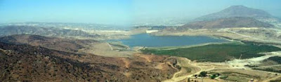
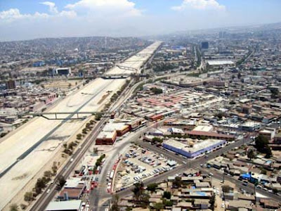
Since the demarcation of the US/Mexico border, the actual limit and physical edge between these two countries has gone through several processes of speculation, bartering and “transaction” that have defined the planning and cultural mythologies of its urban regions. Within these interchanges and contradictions, the geography of the region has been participant in the incessant dialogues of political and territorial debate. Historically, geography did not play an important role in the urbanization of the border, the contiguous geographical context has created asymmetrical bi-national urban pairs; cities on the Mexican side of the border have experienced an accelerated growth compared to their US counter parts. Urbanized sections along the border have experienced an unprecedented and dramatic transformation due to migration and economic factors that began with the industrialization of the region in the middle of the XX century. As urban and industrial development increases in the name of modernization, through relaxed environmental laws and policies, ecological systems are at the brink of collapse. The subjugation of formal and informal development, of which in the last 20 years have reached their critical mass, demands an urgent revisit to the topographical and water reserve sustainability of the region.

Water, in most parts of the US/Mexico border region is a shared preoccupation since the Colorado River supplies a significant amount of cubic meters to the urban regions of Mexicali/Calexico and Tijuana/ San Diego. Tributaries that bifurcate from the river extend and cross national borders throughout their trajectory. Similar to the exchange of goods and labor, the issue of water rights and treatment has been subjected to bi-national politics that affect the future development and growth of these cities. In the city of Tijuana, water and topography are part of the violent process of development as witnessed in informal and squatter communities that demand the local government for infrastructure to access to the precious liquid. While these demands are made possible, topography is engaged in a continuous battle with private housing developers who cut and grade canyons and water sheds for higher profits in the name of social housing. This constant ecological battle is also staged at the institutional level through the constructions of grand urban projects that channel the Tijuana River through concrete canals that divide and incise the urban landscape of this border city. To the north, San Diego’s relationship with topography and water has been one of a simulated symbiosis. Large extension of territory buffers the county from its distopic neighbors, Tijuana to the south and Los Angeles to the North. The green and thirsty lawns of suburban sprawl gated communities, a semiotic element of the American Dream, consume 70% of a household daily water use. In the 70s, Kevin Lynch created a report titled Temporary Paradise, describing the possible links between community development and inland topography as well as ocean front and urban development. The San Diego coast line has been reshaped and enclosed by the naval industry making difficult the possibility of San Diegans to have a natural relationship with their coast and creating their earthly paradise. As we move back and forth across La Linea (the line) the relationships and strategies between geography and urban development is dealt quite differently due to structural differences between both regions and countries. In the border cities of the US, national policy determines development while in the Mexican side; border localization is a dependent factor. The border is a space of paradoxical encounters, far from achieving synthesis. Within the structural paradigms, students will engage in the production of research and the conceptualization of development patterns that surge from these volatile and informal acts of urbanism.
Welcome to LA LINEA.


